 Syken metatietopalvelu
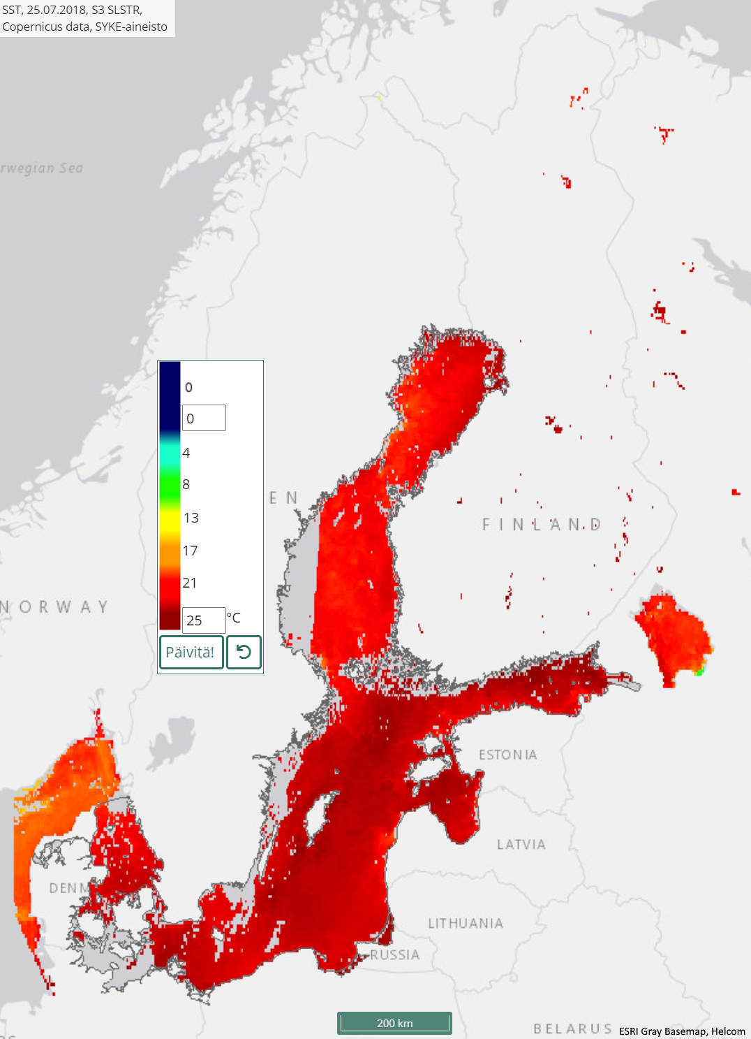
Itämeren ja Suomen järvien päivittäinen pintalämpötila-aineisto (Sentinel-3 SLSTR) 2017– / Daily surface temperature of the Baltic Sea and Finnish lakes (Sentinel-3 SLSTR) 2017–
[FI] Satelliittikuvilta seurataan Itämeren ja Suomen suurimpien järvien (79kpl) pintalämpötilaa jäättömiltä ja pilvettömiltä alueilta. Aineisto kattaa myös lähialueiden järviä, muun muassa Laatokan ja Peipsjärven.
Pintalämpötila on laskettu EUn Copernicus-ohjelman Sentinel-3 satelliittisarjan SLSTR-instrumentin (Sea and Land Surface Temperature Radiometer) aineistoista. Lämpötila on laskettu kahden termisen aallonpituusalueen havaintojen avulla käyttäen ns. Split Window-menetelmää. Pilvet tunnistetaan ja pilviset alueet poistetaan LB1-aineiston pilventunnistustasojen sekä manuaalisen tarkastuksen avulla. Pintalämpötilahavainnot tehdään yöaikaan, jolloin ne vastaavat hyvin asemahavaintoja lähellä pintakerrosta. Kuvien maastoerotuskyky on noin 1 km x 1 km.
Aineisto koostuu vuodesta 2017 alkaen tehdyistä päivittäisistä tulkinnoista. Vuodesta 2019 lähtien aineistoa on tuotettu ympäri vuoden jää- ja pilvitilanteen salliessa. Aineistossa on mukana ne päivät, joilta on saatavilla virheetöntä satelliittidataa.
Aineisto kuuluu SYKEn avoimiin aineistoihin (CC BY 4.0).
Käyttötarkoitus: Itämeren ja Suomen järvien pintalämpötilan seuranta.
***
[EN] Satellite observations are used to monitor the sea surface temperature (SST) in the Baltic Sea. Sea surface temperature dataset covers daily the non-cloudy ice-free sea areas and many of the largest lakes in Finland (79 lakes). Dataset also includes Lake Ladoga and Lake Peipsi.
The dataset is based on the observations by Copernicus programme Sentinel-3 satellite series SLSTR (Sea and Land Surface Temperature Radiometer) instrument. Finnish Environment Institute (Syke) has produced the dataset by using Split Window method and removed the areas covered by clouds. Clouds are identified and removed with L1B product cloud detection layers and thourgh manual inspection. The spatial (ground) resolution is ~1 km x 1 km.
The dataset covers daily observations from year 2017. From 2019 on, the dataset covers all non-cloudy and ice-free observations throughout the year. Dataset includes those days, where errorless satellite data is available.
Purpose of use: Monitoring water surface temperature of the Baltic Sea and Finnish lakes.
***
WMS-palvelin / WMS service endpoint: https://geoserver2.ymparisto.fi/geoserver/eo/wms
WMS-taso / WMS layer: EO_SST
Simple
Identification info
- Title
-
Itämeren ja Suomen järvien päivittäinen pintalämpötila-aineisto (Sentinel-3 SLSTR) 2017– / Daily surface temperature of the Baltic Sea and Finnish lakes (Sentinel-3 SLSTR) 2017–
- Date (Publication)
- 2017-05-01
- Point of contact
-
Organisation name Electronic mail address Role Suomen ympäristökeskus / Finnish Environment Institute (Syke)
Point of contact
-
SYKE resource classification
-
-
Satelliittihavaintotieto
-
- Keywords
-
-
Ei-Inspire
-
TARKKA
-
STATUS
-
status assessment
-
Meriopas
-
Seaguide
-
Resource constraints
- Use constraints
- Other restrictions
- Other constraints
-
Creative Commons Nimeä 4.0 Kansainvälinen
[FI] Syke on mainittava lähteenä, jos tuotteita käytetään julkaisuissa tai esityksissä tai saatetaan muulla tavoin yleisön saataviin.
Sentinel-3-aineistoihin perustuva pintalämpötila: "Syke-aineisto, sisältää muokattua Copernicus-dataa (vuosi)"
Lisätietoja: https://wwwi4.ymparisto.fi/i4/fin/eowiki/aineistojen_kayttoluvat.html
[EN] Syke must be cited as a source if the products are used in publications or performances or otherwise made available to the public.
Surface temperature based on Sentinel-3 data: "Syke data, contains modified Copernicus data (year)"
More info: https://wwwi4.ymparisto.fi/i4/eng/eowiki/license_information.html
- Access constraints
- Other restrictions
- Other constraints
- no limitations
- Spatial representation type
- Grid
- Metadata language
- English
- Topic category
-
- Environment
- Inland waters
- Oceans
Temporal extent
- Begin
- 2017
Spatial extent information
))
- Unique resource identifier
- EPSG:4326
- Codespace
-
EPSG
- Distribution format
-
- GeoTiff ( -)
Digital transfer options
- OnLine resource
-
Protocol Linkage Name tarkka.syke.fi Tarkka-palvelu/service
https://meriopas.ymparisto.fi/meriopas Meriopas / Seaguide
https://geoserver2.ymparisto.fi/geoserver/eo/ows?service=wms&version=1.3.0&request=GetCapabilities GetCapabilities-dokumentti
https://wwwi4.ymparisto.fi/i4/fin/eowiki/aineistot_aineistot.html Lisätietoa Syken EOwikissä
https://wwwi4.ymparisto.fi/i4/eng/eowiki/datasets_start.html More information in Syke's EOwiki
https://geoserver2.ymparisto.fi/geoserver/eo/wms?service=WMS&version=1.1.0&request=GetMap&layers=eo:EO_SST&time=2019-07-25&styles=&bbox=7.498,51.5,31.501,66.503&width=768&height=480&srs=EPSG:4326&format=image%2Fpng%3B%20mode%3D8bit WMS-esimerkki / WMS example
https://www.syke.fi/fi/ymparistotieto/avoimet-rajapinnat/satelliittihavaintojen-rajapinnat Satelliittihavaintojen rajapinnat/EO web map services
- Hierarchy level
- Series
- Statement
-
Kaukokartoitusseurantojen tuloksena syntynyt pintalämpötilatulkinta, joka pohjautuu Sentinel-3 SLSTR -satelliittikuviin. Vuodesta 2017 eteenpäin koostuva päivittäinen pintalämpötila-aineisto.
Prosessointihistoria:
Pintalämpötilat on tulkittu Sentinel-3 SLSTR-satelliitti-instrumentin aineistoilta. Alkuperäinen satelliittidata on ladattu Euroopan avaruusjärjestön (ESA) latauspalveluista. Sykessä niistä on laskettu lämpötilatulkinnat.
Metadata
- File identifier
- {8EAB0767-CE3D-41E6-8791-EC11B1B00911} XML
- Metadata language
- Finnish
- Character set
- UTF8
- Hierarchy level
- Series
- Date stamp
- 2026-11-18T14:38:29.188079Z
- Metadata standard name
-
ISO19115
- Metadata standard version
-
2003/Cor.1:2006
- Metadata author
-
Organisation name Electronic mail address Role Suomen ympäristökeskus / Finnish Environment Institute (Syke)
Point of contact
Overviews
Spatial extent
)))
Provided by
